Saturday, February 13, 2016

We Moved!

Cue theme song to "The Jeffersons" ...

Image result for The Jeffersons

We have moved to a classy new spot over at Insteadofdoingdishes.com!

The stories posted here will slowly but surely be moving over there in addition to our newest adventures, as they occur.

Our time at Blogspot was great...but you should check out what is going on at the new site!

As always, thank you for your support!

~Rosemary

P.S. Our Facebook and Instagram are still the same...have you liked us there yet??

Saturday, May 9, 2015

Taken from the Old Trace

"Leave a place the way you found it...take nothing with you..." Things a Park Ranger has told us for 300 Alex... but sometimes it can not be helped!

Along the Natchez Trace Parkway there are small sections of the original 444 mile trail accessible to hikers.  One of these sections, about 20 miles north of Natchez, MS, is  called the Potkopinu.


 This three-mile section of the Old Trace was once traveled by boatman on their way home.  Before that, the Native Americans used the Trace to follow herds of animals to warmer weather.  Now it is a very peaceful hike on a warm spring day!

tricked convinced my sister into tagging along with me and my two boys (five and two).  I was not totally convinced that they could handle a three mile trek...but we set off in good spirits!
Things I learned while on this hike:
  1. Having a backpack of bottled water and a good pair of tennis shoes does not a seasoned hiker make.
  2. Snakes are not the only animals that come out in the Spring.
  3. Downed trees can make for an interesting hike.
Now, allow me to elaborate on the above list.

I thought I was pretty well prepared for this short hike through the woods.  I had a backpack, bottled water, a cell phone, and a first aid kit.  What else would you need?  How about a walking stick...or bug spray...or a stroller for when your two year old decides three miles is just to much for him!. I was pretty unprepared in the ways of the hikers...

I knew snakes would be out.  I went into the hike LOOKING for snakes and the Potkopinu did not disappoint.  Luckily we only saw one!
Yeah...that's a poisonous one! Good thing my five year old saw it first and screamed like a girl, causing me to scream, and my sister to go into attack mode.  Sense took over quickly and we let coiled snakes lie...we gave it a WIDE berth and hurried along. 

Let me tell you what was more abundant than the snake...more aggravating...and enjoyed rides home with us...

TICKS! Good Golly Miss Molly! THE TICKS!!!

We were plucking the jokers off left and right the whole three miles.  Big ticks...little ticks...fast ticks...ticks already having dinner...it was terrible!

(Cue Brad Paisley's "Check You for Ticks" song)

We basically stripped the children in the parking area to debug. Once home we still found a dozen more!  Needless to say, bug spray will now be applied religiously before any more outings! If you see us out and about (hiking, touring, shopping), we will most likely smell of bug spray from here on out...

The original portions of the Trace are pretty much left to their own devices.  As you hike, you can see a few places were someone with a chainsaw came through and cut up fallen logs in the path.  This has not happened recently.

This is an example of a fallen tree that is above the trail.  Not all trees were so lucky.  We climbed over, and in some cases, crawled under, several downed trees during our walk.  My five year old considered each obstacle a challenge that he personally had to figure out how the group was going to pass.  

All in all it was an adventure to remember and we really enjoyed it!  The trail is well marked..this means about the time you start questioning your location, an arrow appears to reaffirm you are traveling in the correct direction. The scenery varied from deep trail to creek beds to forest floors.  I was more focused on bugs and critters than pictures so I didn't take to many.  But I did get this one...
My boys...racing to the car at the first sign of civilization... at the end of the three mile trek along the Potkopinu.

Until next time
~Rosemary

Friday, February 13, 2015

This is not an ad for Tylenol...

Although I did down a handful right before writing this.

And once you have read what all we did today...you may even need some too!:)

Today was the big Clean-up Day in Rodney, MS.  If you aren't sure where that is, don't worry...99% of the world is right there with you.  We have visited Rodney before, and this is what we saw...
inside Baptist Church
Rodney Presbyterian
Baptist Church

Stone from Cemetery

These photos were taken a few years ago.  Since then, there was a massive flood, seasons changed, and time has passed.

Today, we were lucky enough to attend a Clean-Up Day in Rodney put together by Mrs. Mary from the Rodney, Mississippi Remembering Facebook Page.

More than 60 volunteers used this BEAUTIFUL Saturday to revive, unearth, scrub, and clear out several areas of the former town of Rodney.  The structures included the Presbyterian Church (or cannon-ball church), the Baptist Church, and the Masonic Lodge.  The outsides of all these buildings were also worked on, as well as the Rodney Cemetery.
Group Photo by Paul Wade
In case you can't tell, that is me rocking the MSU sweatshirt just right of center...oh and Heather is next to me. :)

The Instead of Doing Dishes Team (yes...we are our own team) was assigned to the Baptist Church. When we got there, a fellow volunteer had blown out the debris that enters through the broken panes of glass.
All of the volunteers worked extremely hard!  The goal is to save the few buildings left in this ghost of a river town.


I worked in the former slave balcony.  Let me tell you...when I got to the top of those steep, narrow, winding steps...it was a shock! I was ankle deep in dust, dirt, leaves, and who knows what debris!  Thankfully, some other volunteers braved the slanted floor and narrow steps to help shovel out the balcony with me! It truly was a group effort!
Jessica White
Heather
On the ground, Heather and our new friend Jessica worked on removing dirt dauber nests and spiderwebs from the walls and windows of the Baptist Church. There was so much work to be done here.  Several other volunteers came in throughout the day but we were so busy and they got away without being photographed!

One of the disappointments of the day...

These are the pews from inside the Baptist Church.  They were in such disrepair that we could do nothing with them today.  Maybe a skilled carpenter will one day donate their time and expertise to help return them to their rightful places...one day...

We did get to drive around a little before leaving.  I even got to visit the Rodney Cemetery for the first time! First thought - What a HIKE! Straight uphill...whew! Second thought- BEAUTIFUL! I did not get to see it before the clean-up crew got to it...but it looked amazing.  Those folks worked really hard saving and unearthing stones that have been there since the early 1800's! 

This bluff side cemetery is one of the post peaceful places I have ever encountered (even with the chainsaws going:)) No wonder early residents of Rodney hauled their family members to the top for their final resting places. 
A lot of the stones are damaged in some shape, form, or fashion. The above was a picture I took of a stone that I found unique and lovely!

                                                      
After of day of ladder climbing, scrubbing, singing, discovering, and making new friends, we called it a day.  We like to think we left this old beauty in a little bit better condition...we do know it smelled better!

                                                
Maybe one day you will find your way down the gravel roads leading to Rodney.  Feel free to grab a broom (we left some for your convenience:)) and sweep out a few leaves or dusty corners while you soak up the history of this once bustling town.

Until next time!
~Rosemary

Thursday, February 5, 2015

Why We Do What We Do

Why do we do it?
Downtown Natchez

Why do we drive all over creation? Why waste the gas?

Why do we take pictures of every little thing?  Why pull over and crawl through the weeds for a glimpse of a run down, falling in, elderly building?

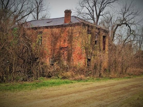
Today, the answer came to us in the form of Nil Desperandum. If you recall, the lasts time we played around in Louisiana, just across the river from Vicksburg, we stumbled upon this behemoth in the bushes.
At the completion of today's travels, we discovered that she stands no more.  Nil Desperandum once stood proud in the Louisiana delta, but now the two chimneys are all that remain. Or are they?  We also have the pictures!  Buildings, left to their own devices, crumble under the weight of overgrown vegetation and rotted material.  Yet we spend days traveling the pot-hole riddled, wash-boarded, gravel roads photographing just such places so that they may live on forever.

But I get ahead of myself.  We ended at Nil Desperandum, but we started in Natchez.

Now, we have been to Natchez many, many, many, many times. Yet we still find things to check out EVERY TIME! Started with a church on the way down town.
                                                   

Holy Family Catholic Church can be found in downtown Natchez.  This beautiful old building has been here since before 1900.  Imagine the worshiping that has occurred in this structure.  Across the street is the Rhythm Club Fire Museum.  We did not take the tour today, as we had other plans (yes, we do sometimes stick to a plan), but we will return.


Finally, we crossed the Mighty Mississippi River and headed north.  Once out of Ferriday, Louisiana we were in uncharted territory...at least for Instead of Doing Dishes :). First stop was Clayton, Louisiana where we crossed an old vertical lift bridge...

before turning around to get pictures.  This engineering is not something we have seen much of on our travels, so we were impressed.

We choose a road that paralleled the river and headed north, seeing as we have been south along the river before. Hwy 65 runs from Ferriday to Tallulah, LA.  Now, you know us...we did not stay on Hwy 65, but this was the main road we took through the flat plains of Louisiana.

As we bobbed and weaved we found a few old plantation homes. We loved this one.

There were not signs... we are not even quite sure where we were...other than Louisiana, but either of us would snap this bad boy up in a hurry.

We stumbled upon a pretty famous home, at least to us, that has been shut down for renovations.
Winter Quarters was once a residence of Haller Nutt.  Nutt is most known, to us, for his building, but never completing Longwood Plantation in Natchez.  We really wanted to get in to see this house, and hope that one day they will reopen to the public.

Most of what we encountered on this days journey were churches.  Plantations often built their own churches for people to worship close to home. We found there are several old churches still standing! Some had names, some did not, but all were worth the stop to take a picture!
            

As we took the long way around St.Joseph Lake, we also found the marked site of a former mission.  From the signs, I deduced (did I really just use that word...gonna have to back off the Sherlock watching!) that the mission here was the predecessor to St.Patrick's Mission in Fort Adams, MS.
The building, although antique itself, was not part of the original mission.  Interesting fact, if you zoom on the above photo one sign is in English and the other Spanish.  The Spanish sign is in much better condition than the English.  When we stopped, I first tried reading the better looking of the signs when I realized it was not in English.  While Heather was taking pictures, I began slowly reading the English version, which Heather didn't know was there as I was reading.  She was, at first, very impressed with my ability to read Spanish having never learned the language! HA I should have kept my mouth shut and not pointed out the other sign...I might get her next time!

Sometimes while traveling, we find things that remind us of home or other places we have been.

This was a "reminder" that Heather could have lived without.  I believe we saw the smoke stack of Grand Gulf Nuclear Plant for most of the trip.

Poor Heather...this day was just totally against her...because not to much further down the road we stumbled up THIS (which thrilled my soul!)
If you recall we have covered the Mississippi side of Old Ulysses' march to Vicksburg during the Civil War. We also, found out there was a Louisiana side to the old fellow's travels.  We have not yet followed it, but I believe we found the tail end today around Winter's Quarters.  One day we will complete this!

Not only was my day made, thanks to Grant's meanderings, but my youngest got the thrill of his short life when we were buzzed by "Dusty Crophopper"!
Heather got some great shots and I plan on blowing these up for my two-year old's wall.  He talked about this the entire way home.

Our last detour, once we got back to Mississippi was a trip down Letourneau Road in Warren County.
There are some amazing river shots to be had from here.

If I remember correctly I believe there were three barges within sight.  It was pretty spectacular.

We survived another trip!  I believe it is time to give the Blue Mazda a check up before out next excursion...she works harder than the rest of us after all!


So this is why we do it.

We find things that other have forgotten...or may not have even known was there without us.  We share the experience so that those who can not spend hours roaming the lesser known roads can follow along at their own pace.

We do it for places like Nil Desperandum. Future generations will drive by and see two chimneys and wonder what was there, but we can look back at our photos and KNOW what was there.

Until next time!
~Rosemary

Sunday, January 25, 2015

From Fort to Last Port

Today was totally planned.

If by "totally planned" you mean we meant to spend the day driving around, we just weren't quite sure where we would end up.

First thing is to check out Fort Adams, MS in Wilkinson County, between Woodville and the Mississippi River.
July 1863 from Frank Leslie's Illustrated Newspaper

We did not make it all the way to Fort Adams before Heather had me pulling over for a cemetery she spotted clinging to a hillside.  The Ward Cemetery is between what appears to be an old road and the new road.  Spread out and barely hanging in there, it is very neglected.  The stones mostly date to the '60's.  We plan on returning to catalog the memorials there in the future when the ticks are not quite as prevalent.


Arriving in Fort Adams, we quickly passed up "Bubba's One Stop" to grab pictures of St. Patrick's Catholic Church.
                                                
The church was built in 1900 and even with the windows boarded up you can tell the stained glass windows were lovely.  I read somewhere that the flooding of the Homochitto River, which happens pretty often, was the reason for the boards.  The stained glass is being protected.

We found out later that we totally missed a cemetery next to the church.  I  can only blame this on... well...I really have no idea how we missed it!  According to Find A Grave, Henry E. Harris was laid to rest here in 1913.  His is the only stone standing, but it is believed that there are more buried here.  Headstones do not stand up well to constant flooding...

Ok, now for some history on Fort Adams.  This area now known as Fort Adams has changed hands many times.  Each new occupation brought with it a new name.  Originally established in 1698 by Catholic priests who lived among the Natchez and other local Indian tribes, it was known as St.Patrick's Mission. The French called the area Davion's Rock for Father Davion.

This was the American port of entry along the Mississippi River for a long time, due to the fact that New Orleans was not controlled by the United States.

When the British moved into the area in 1764, it became known as Loftus' Heights. The fort was built in 1799 when General James Wilkinson came to the area to keep an eye on the American/Spanish boundary.  (Wilkinson is who the county is named for.)
                                              

Considering the lack of historical markers or information on site, a lot of important things occurred at Fort Adams.  The Treaty of San Lorenzo, which defined new borders between the U.S. and Spain was signed at Fort Adams.  Many treaties with the Choctaw Indians, including The Treaty of Fort Adams that traded Choctaw land for land east of the Mississippi River, were signed here.

Once the Spanish threat was gone, Fort Adams was no longer needed, but the nearby town retained the name.  Like most river towns, it was prosperous until a shift in the ever changing bed of the Mississippi took the river more than a mile away.


Next stop, Pond, MS.  We stopped here because there is a lovely set of restrooms at the Clarks Creek Nature Area! we were curious about the trails and waterfalls in the area.  We, as usual, were not prepared for a hike, so this will be something else we take in at a later date, but there really are some great bathrooms here!.
The Pond Store was built in 1881.  The only thing in this little corner of the world was the store and a home...and lots of animals...


Thanks to our good friend Mary, at the Rodney, MS Facebook page, we learned that a stop was needed on the trip from Woodville to the port at Fort Adams, so a pond was dug, thus the name Pond, for the animals making the journey to the river.

We continued on our way and stumbled upon Bethel Farms Plantation. The stand out front promises a vegetable stand during the growing season!

We made our way back to Woodville, took a few pictures and decided to head to Natchez (I am sure food was involved in this decision:).
                                                 

We drove along Lower Woodville Road to get back to Natchez.  This has got to be one of the oldest roads we have ever taken.  Last time I was at this end of Lower Woodville it was dark and rainy.  This time I could see just how deep the road was.  It was almost like driving through a tunnel!

On a spur of the moment decision, we decided to cross the Mighty Mississippi River and take another attempt to find the Mamie S. Barrett.  Several people have posted pictures before of this beached behemoth, but our last attempt to find her left us lost in New Roads, LA and a long way from home.
A co-worker of Heather's gave her some directions, which I am proud to say she relayed to me flawlessly which was unusual. And we found her!
Mamie S. Barrett, built 1921, washed up in 1993
 We hear she is for sale...if anyone wants to work her over, make her seaworthy, and offer us a free tour:).

Here is the view of the river from Deer Park, LA.  No wonder the old towboat decided to make her final rest here...

So that was our journey today.  From the fort that once brought Christianity to the Natives to the final port of call for an aging tugboat, all in all it was a pretty awesome day!

Until next time
~ Rosemary